On his pop-up version of Puget Sound geologic history, Ray Wells gives the Beaver State a twist.
“Oregon has to rotate clockwise to get out of the way of California, squeezing Washington along the Seattle fault,” the geologist explains, the laminated surfaces of his map buckling and sliding obligingly. “It acts as a battering ram, shoving Washington into Canada.”
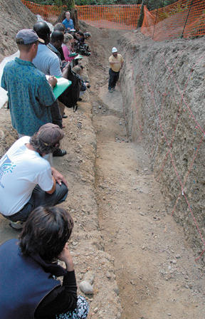
To judge from the excitement of those gathered to view the newly unearthed segment of the Seattle fault, you’d think this refresher course in plate tectonics was an announcement that the Big One was about to happen.
In fact, says a beaming Brian Sherrod, head geologist for the U.S. Geological Survey, the excavation on the IslandWood campus offers a thrilling glimpse back at the Pretty Big One – or Two, or more – that let loose some 1,100 years ago.
“This is among the first dated evidence for surface-breaking earthquakes in the Puget Sound lowlands,” Wells says.
Watching from the back of the pack of reporters, scientists and congressional staffers, grad student Matt Brewer sidles up to Carol Grisham.
“I’m glad to be a part of this,” he says quietly to IslandWood’s executive director. “Thank you.”
It’s a discovery worth being a part of. The excavation has already caused the foundations of local seismic science to tremble.
At the Bainbridge segment of the fault, once projected to be the northern-most edge of the east-west running seismic zone, geologists have exposed a north-facing line, suggesting that the the fault system may reach as far as Kingston.
“This trench in particular is forcing us to re-evaluate the Seattle fault,” says Sherrod.
It’s exciting stuff – exactly what geologists hoped for when they started the excavation in mid-August, and nothing that they expected.
That’s just how Brewer and Grisham feel – for different reasons.
While the hard-hatted men in the trenches are redrawing Bainbridge’s geologic map in the service of earthquake preparedness, these whisperers may be the ones to turn Bainbridge’s big dig into a lasting asset for the island.
Brewer and some of his classmates – the second crop of students to enter IslandWood’s advanced degree program – are campaigning to keep the trench open permanently, to bring hands- and eyes-on geology into IslandWood’s environmental education programs for kids.
The possibilities of the exposed fault became clear on the grad students’ first visit to the site – their first campus tour, just weeks into their eight-month graduate program.
“When we talked to Brian (Sherrod), the USGS scientist there, he was pointing out the historical data associated with (the trench). I noticed it had many of the introductory principles of geology,” said Rob Engel. “It’s an absolutely beautiful fault line.”
“Beautiful” because, to a geologist – or to a fifth grader equipped with some basic rules for reading earth’s history – it’s obvious that the standard state of geologic affairs – horizontal layers of material stretching out in all directions – has been seriously disrupted here.
A clearly defined bedrock layer, a conglomerate of sand and basalt some 13 million years old, has been snapped like a pencil and thrust upwards, burying beneath it the smooth till deposited 16 thousand years ago with the recession of the glaciers.
Old material on top of young, once-flat layers cracked and twisted – it’s rock science’s forensic evidence, the clearly visible remains of a major earthquake.
The window on that past is a teaching tool the new grad students were determined not to see shuttered.
“Geology is a science that’s very visible, and (the trench) offers that chance,” Brewer said. “Earthquakes happen in the Northwest, and that’s something that people who live here need to be aware of. Seeing the effects makes it real.”
Within a week of their first viewing, the students had submitted a proposal to integrate the trench into the school’s elementary-age education curriculum.
“It was unexpected for everybody,” said grad student Abby Burrows. “We didn’t want to see the opportunity lost. That’s why we moved on it really quickly.”
“Based on their proposal, our science coordinator started talked with USGS (about keeping the trench open),” said graduate Program Coordinator Kristin Poppo. “This energy started to build behind the possibility of saving the trench.”
The chief obstacle: safety. The two earthen tiers and rough-cut three-foot wide ditch that gave access to the fault had been carved out as a temporary research station for trained geologists, not for excited elementary school students (though the former seemed as giddy as the latter as they extolled the virtues of the site.)
Those concerns, and the money required to address them, are still the subject of discussion between USGS and the school.
Still, both graduate students and staff are hopeful that a permanent structure, perhaps a plexiglass viewing wall, can eventually be put in place.
But the proposal has already sparked hopes that students attending the school’s outdoor education programs will benefit from the find.
And while the fate of the trench itself is still in question, the school’s partnership with the USGS has already benefited the curriculum, said science coordinator Karen Masamoto.
“In cooperation with USGS, IslandWood will…maintain a record of local seismicity and the geology of earth movements on Bainbridge,” she said. “Seeing this earthquake research in progress will help children understand what science is really about.”
It’s already been an education for the grad students. Both Engel and Brewer plan to explore the area’s geologic history in their independent research projects.
“The tie between geology and archeology is immense,” Engel said. “The actual placement of this fault lines ties into the movement of native peoples here.”
For Burrows, the experience has affirmed the value of her IslandWood education. “The fact that (the trench) has gone from one simple idea into part of the curriculum – it confirms the inkling I had that I’d be growing as an educator.”


