Public Works illustrates needed utility upgrades by painting up Winslow Way.
Put away the hose – the surface of Winslow Way was not graffitied by a gang of chalk-wielding six-year-olds.
The culprits actually were city employees who, to illustrate some of the current problems plaguing the street’s aging utilities, began painting the pavement before daybreak Tuesday.
“It’s just to give people an idea of what’s underground and to get people to come up ask questions,” said city planner Chris Wierzbicki, of the colorful representation of Winslow Way’s viscera.
Planners will man a booth at today’s parade – they did so yesterday as well – to answer questions and explain their visual aid. In front of Winslow Drug, for example, run two parallel yellow lines that suddenly jut toward the center line.
A brief explanation is written nearby: “sanitary sewer break – yuk!” Similar drawings can be found along the length of the road, which is set for a major overhaul in spring 2009.
The City Council in April approved nearly $1 million in funding to begin design work on the project. Sewer, water and storm drainage below the street need to be repaired or replaced, and doing so will require the tearing up of of the street. In light of that, the city also plans to make improvements on the street’s surface.
Work will take place mostly on Winslow Way between State Route 305 and Grow Avenue. Seattle firm Heery International began working with city planners in April to craft early visions for the project. Feedback from parade-goers will influence design, which is nearly 15 percent finished. The next public meeting will be on Aug. 1. Planners hope to have the design 30 percent complete by the end of the year, Wierzbicki said.
Among the proposed elements of the plan are wider sidewalks, narrower car lanes and more street trees.
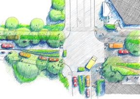
The most dramatic changes would be to two major intersections on the street.
The first, where Winslow Way meets Madison Avenue, would place a planted divider between the two lanes on Winslow Way, west of Madison.
The goal is to improve the alignment of the lanes, which now are skewed, and to make it easier to introduce a traffic signal at some point in the future, Wierzbicki said.
The change would require an easement from Eagle Harbor Congregational Church to cross the edge of the church grounds.
At the other side of town, where Winslow Way intersects with Ericksen Avenue and Bjune Drive, there are two possibilities.
One would be to realign the intersection so that the two north-south running streets meet head on.
Doing so would require the acquisition and demolition of the building at the southwest corner of the existing intersection.
Because pursuing that option would be more complicated and expensive, the current preferred alternative is to add a planted divider in the center of Winslow Way beginning at Ericksen and stretching eastward.
That option would eliminate left turns to and from Bjune, Wierzbicki said, and may include some traffic revisions on lower Bjune so that circulation wouldn’t be hampered by the new turn limitations at the corner of Winslow Way.
Sidewalk width would nearly double along Winslow Way. The extra room would improve passage for pedestrians and would allow for more street trees. Curbs may be eliminated from some areas of the street, with the trees separating pedestrians from cars. Other areas could have stepped and rolled curbs.
The largest trees would be at the east end of the street, beginning near 305.
The idea, Wierzbicki said, is that the tree canopy would stretch over the street, creating an entry portal to downtown.
Also under consideration are raised crosswalks that would be more visible and would be easier for people with disabilities to navigate.
Parking would still be angled along on both sides of the street. There would be 13 new spaces at the west end of the street, though 15 would be removed from the heart of downtown.
Based on the current plans, the total number of spaces would be reduced by three, but Wierzbicki said the ultimate goal is to not lose any spaces.
One possibility is having back-in angle parking instead of front angle parking. That option would compensate for the reduction in lane space, Wierzbicki said, though people in general prefer front angle parking because it’s more familiar.
Reduced lane space also would change the habits of delivery drivers, many of whom now commandeer the center lane while they make deliveries to local merchants. Along with dedicated spaces for delivery trucks, the city is working with delivery drivers to determine how they could shift their practices.
Bicycles would be served by a combination of dedicated bike lanes and shared bicycle and car lanes; new bicycle parking would be added.
Plans also call for the introduction of bio-swales and rain gardens in certain spots. A “runnel” – a narrow channel at the center of two inward sloping lanes – that would feed a rain garden, could be included near Grow.
The city has hired a Seattle artist to create a preliminary art plan for the street that would incorporate island artists.
Wierzbicki said the city wants to get as many comments as possible before reaching the 30 percent point, which is much further along than most people might think.
“In terms of public input,” he said, “30 percent is basically the entire design.”
*****************************************************************************
Streetscape
View plans and submit comments at the parade booth or at winslowwaystreetscape.org.